ACCESS recommends solutions to critical ocean problems to resource managers, policy-makers and conservation partners, and mobilizes public support for marine conservation. ACCESS focuses on the following conservation and management issues:
Saving Whales from Ship strikes
ACCESS data has been used to identify whale habitat within Cordell Bank and Greater Farallones National Marine Sanctuaries and inform shipping lane changes in 2009-2013. The new lanes decreased spatial overlap between vessel traffic and high-use whale habitat by about 70%, but increased traffic density over critical feeding areas. Since then, the National Marine Sanctuaries implemented a voluntary vessel speed reduction program to decrease the likelihood of deadly strikes within the shipping lanes. Point Blue is currently using ACCESS data to evaluate the efficacy of the vessel speed reduction and to recommend additional management measures that will help save more whales off San Francisco, and impact whale conservation along the US West Coast.
Reducing Whale Entanglements
ACCESS data can be used to identify Dungeness crab fishing areas within Cordell Bank and Greater Farallones National Marine Sanctuaries to decrease whale entanglements. On the U.S. Pacific Coast, whale entanglements have increased dramatically, from 8-10 entanglement reports in 2000-2012 to 32 in 2014, 61 in 2015 and 71 in 2016. The combined use of ACCESS whale habitat and crab pot fishing areas would allow us to identify high entanglement-risk areas to save whales. Our goal is to provide tools and recommendations to the California Department of Fish and Wildlife for the temporal and spatial adaptive management of the Dungeness crab fishery during high entanglement-risk years.
Protecting Wildlife Hotspots
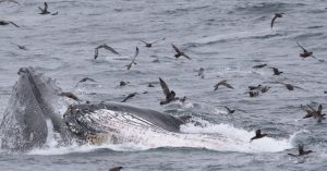
ACCESS data has been used to identify seabird and whale hotspots within Cordell Bank and Greater Farallones National Marine Sanctuaries to protect wildlife and decrease conflicts with existing and proposed new human uses. Seabirds breeding on the Farallon Islands feed over the continental shelf to the east of the island and along the shelf break to the west. Seabirds that visit from colonies afar and whales aggregate to feed along the shelf break, particularly in the vicinity of Cordell Bank. Our results show that the most important seabird and whale habitat lies in areas where threats from shipping, oil spills, and proposed offshore energy development remain.
Developing Ecosystem Indicators

ACCESS data on marine invertebrates has been used to develop ecosystem indicators to help track ocean responses to climate change. Marine invertebrates such as copepods, decapods (crab larvae), euphausiids (krill) and pteropods (sea butterflies) are at the base of the food web and respond quickly to changes in ocean conditions. Copepod species common to northern latitudes become abundant in the Gulf of the Farallones during strong upwelling conditions. These northern species are larger and fattier, making them better prey. Copepod populations have been used to give a one-year advance warning of major changes in oceans conditions and have proven useful for forecasting salmon survival in Washington and Oregon. Overall, krill abundance declines during poor upwelling conditions and are replaced by gelatinous species of zooplankton that thrive in warmer waters. Low krill years are generally associated with poor breeding conditions for seabirds on the Farallon Islands
Tracking Ocean Acidification

ACCESS data has been critical in developing new methods to measure ocean acidification (aragonite saturation) in north-central California. About a third of the global carbon emissions have been absorbed by the oceans, resulting in an ongoing shift in marine chemistry known as ocean acidification. Under these conditions, carbonate ion concentrations within the water column are lower, making it more difficult for shell-forming organisms to build their shells. ACCESS data was used to develop an empirical relationship that enables aragonite saturation state to be estimated from existing hydrographic measurements, for which greater spatial coverage and longer time series exist in addition to higher spatial and temporal resolution. Application of this relationship has shown the direct association between low aragonite saturation and upwelled waters and highlights the extent to which benthic communities are already exposed to aragonite undersaturated waters.